Public Lands
The John Muir Trail lies completely on public lands, and so, is owned by the American people. The trail traverses three national parks (Yosemite, Sequoia, and Kings Canyon National Parks) and two national forests (Inyo National Forest and Sierra National Forest). Much of this land has also been designated under the 1964 Wilderness Act, perhaps most notably the John Muir Wilderness and Ansel Adams Wilderness. Near Mammoth Lakes, the JMT also passes through Devils Postpile National Monument.
Parsing the JMT by mileage, approximately 135 miles cross the National Parks, and approximately 83 miles cross the National Forests.
The main access trails and the trails around re-supply sites add 70 miles in the National Parks and 107 miles in the National Forests.
JOHN MUIR TRAIL + ACCESS TRAILS
205 miles in National Parks
190 miles in National Forests
395 miles in Total
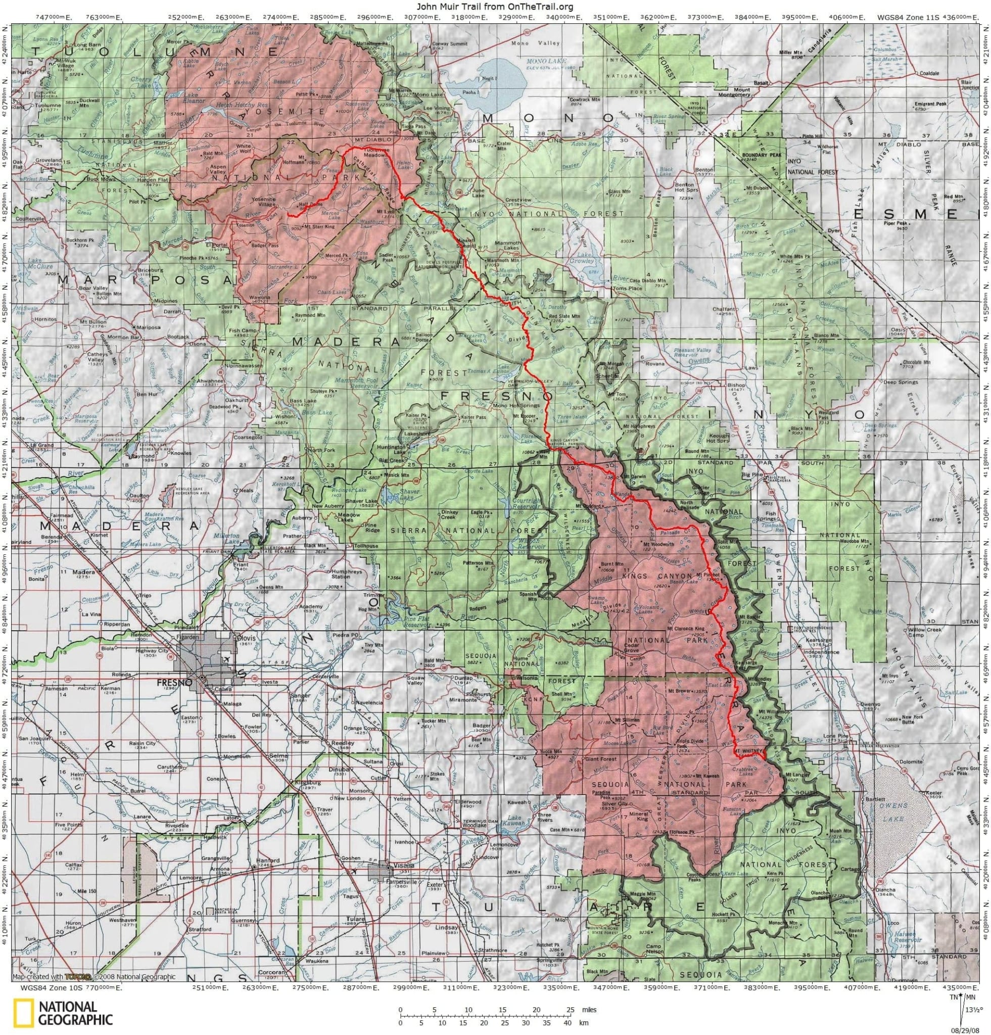
- The red line is the JMT itself.
- The green shaded areas are the Inyo and Sierra National Forests.
- The red shaded areas are Yosemite National Park to the north and Sequoia-Kings Canyon National Park to the south.
Federal Agencies
By federal law, there are two governing bodies to manage our national parks and forests, the National Park Service and the United States Forest Service. They are charged with the care of our parks, forests and trails for the public good. These federal agencies will study and evaluate the needs of the John Muir Trail, its access trails, and the surrounding wilderness and will direct all efforts to repair and maintain the trails and to protect and conserve the environment surrounding it. The JMT Wilderness Conservancy, consistent with the practice of all foundations benefiting public parks and trails, will be fundraising and providing volunteers to support these efforts.
The National Park Service is an agency of the United States government that manages all national parks, many national monuments, and other conservation and historical properties. It was created on August 25, 1916 by Congress through the passage of the National Park Service Organic Act and is an agency of the Department of Interior. The NPS is charged with preserving the ecological and historical integrity of the places entrusted to its management while also making them available and accessible for the public to use and enjoy. The John Muir Trail starts in Yosemite National Park and traverses Sequoia Kings Canyon National Park, both of which are administered and managed by the National Park Service.

The United States Forest Service (USFS) is an agency of the U.S. Department of Agriculture that administers the nation’s 154 national forests and 20 national grasslands, which encompass 193 million acres. It is the USFS’s responsibility to sustain the health, diversity, and productivity of the Nation’s forests and grasslands for future generations. Managing approximately 25% of federal lands, it is the only major national land agency that is outside the U.S. Department of the Interior. The Pacific Southwest Region of the USFS, commonly referred to as Region 5, administers to and manages the two national forests traversed by the John Muir Trail and its access trails, Inyo National Forest and Sierra National Forest.

The Historic American Landscapes Survey (HALS) is a part of the National Park Service’s Heritage Documentation Programs. HALS mission is to record historic landscapes in the United States and its territories through measured and interpretive drawings, written histories, and large-format black and white and color photographs. The NPS oversees the daily operation of HALS and formulates policies, sets standards, and drafts procedural guidelines in consultation with the American Society of Landscape Architects (ASLA). Tim Davis is a historian and author at the NPS who is currently working on a year-long effort to research the origin and history of the John Muir Trail. His work will culminate in a written history and collection of historic photographs and maps which will be made available to the public.